BlueChart g3 HD, HXUS604x, US All & Canadian West, microSD /SD
Mfr # 010-C1018-20
Zoro # G411114102
product price: $208.99
/ea
Free Shipping & Returns
Get a 10% off coupon
Free 30-day returns
Return PolicyGet 30 days to pay with Net 30
Apply NowReal support from real people
Contact our U.S. based teamSpecifications
Product Information
MFR #
010-C1018-20
Zoro #
G411114102
UPC #
753759095789
Country of Origin
United States
Description
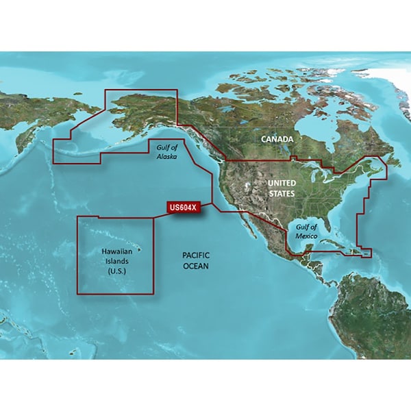
BlueChart g3 HD - HXUS604x - US All & Canadian West - microSD /SD CoverageProvides detailed coastal coverage of the U.S., including the East Coast from Key West, FL, to the Canadian border, and the West Coast from Puget Sound to the Mexican border; Alaska; Hawaii and major inland rivers; the U.S. Gulf Coast to the Mexican border and the Mexican Gulf Coast to the Yucatan. Canadian coverage includes the entire St. Lawrence Seaway, Nova Scotia and New Brunswick. The Great Lakes are covered in their entirety as are the Lake of the Woods. Coverage includes Prince Edward Island, Anticosti Island, Vancouver Island, including the Inside and Outside Passages, the Aleutian and Channel Islands, the Bahamas, the Turks and Caicos Islands, Cozumel, Cuba, Hispaniola, Puerto Rico and the U.S. Virgin Islands.Unparalleled Coastal Chart CoverageProvides industry-leading coverage, clarity and detail with updated coastal charts that feature integrated Garmin and Navionics dataAuto Guidance technology calculates a route using your desired depth and overhead clearance and provides a suggested path to followIncludes Depth Range Shading for up to 10 depth ranges, enabling you to view your target depth at a glanceUp to 1' contours provide a more accurate depiction of the bottom structure for improved fishing charts and navigation in swamps, canals and marinasNOAA raster cartography2 is available as a free downloadable feature via the ActiveCaptain appBlueChart g3 coastal charts provide industry-leading coverage, clarity and detail with integrated Garmin and Navionics data. Also included is Auto Guidance technology, which uses your desired depth and overhead clearance to calculate routes and provide a suggested path to follow - overlaid onto your chart. NOAA raster cartography is also available as a free downloadable feature via the. ActiveCaptain app. It gives your chartplotter paper chartlike views of NOAA-surveyed areas in which individual points of interest are labeled with corresponding longitude and latitude information. Worldwide coverage is available by regions as accessory cards or via download; each region is sold separately.Auto Guidance TechnologyThe Auto Guidance feature calculates a suggested route using your desired depth and overhead
Documents & Resources
Ratings & Reviews
3 Reasons You Can Count On Us

Supplies for every job.
10 million items and the exact one you need.

When you need it fast, count on Zoro!
2 million products ship in 1 day.

Stretch your budget further.
Everyday low prices on the brands you love.