BlueChart g3 Vision HD, VAW450S, The Gulf, microSD /SD
Mfr # 010-C0758-00
Zoro # G011108419
product price: $168.99
/ea
Free Shipping & Returns
Get a 10% off coupon
Free 30-day returns
Return PolicyGet 30 days to pay with Net 30
Apply NowReal support from real people
Contact our U.S. based teamSpecifications
Product Information
MFR #
010-C0758-00
Zoro #
G011108419
UPC #
753759069384
Country of Origin
United States
Description
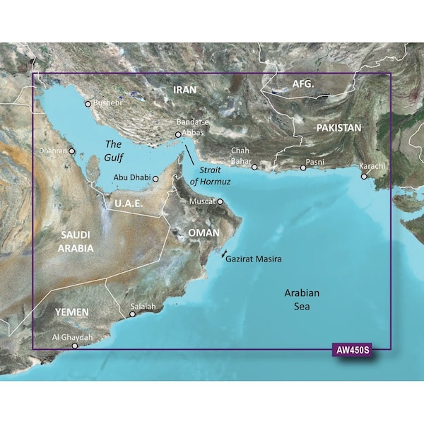
BlueChart g3 Vision HD - VAW450S - The Gulf - microSD /SD Coverage:Detailed coverage of Kuwait, Saudi Arabia, Qatar, United Arab Emirates, along the southern coast of the Gulf, including Al-Fuhaihil, Ad-Dammam, Bahrain, Ad-Dauha, and Abu Dhabi. Coverage of Iran along the northern coast of the Gulf including Bushehr and Bandar-e Abbas. Coverage of the Strait of Hormuz and the Gulf of Oman. General coverage of the Arabian Sea from Qamar Bay to the Delta of the Indus River. Our Premium Chart OfferingDerived from official charts and private sources to provide navigational aids, spot soundings, depth contours, tides and currents, and detailed harbors and marinasGarmin Auto Guidance technology shows a suggested route to a destination Depth Range Shading for up to 10 depth ranges enables you to view your target depth at a glanceUp to 1-foot contours provide a more accurate depiction of the bottom structure for improved fishing charts and navigationShallow Water Shading feature allows for depth shading at a user-defined level to aid in navigationUnique 3D views like MarinerEye and FishEye provide additional perspective both above and below the water lineHigh-resolution satellite imagery of ports, marinas, bridges and navigational landmarks for superior situational awarenessAuto Guidance Auto Guidance technology quickly calculates a suggested route using your boat's dimensions and a suggested path to follow.Depth Range ShadingDisplays high-resolution Depth Range Shading for up to 10 depth ranges so you can view your designated target depth.Detailed ContoursBlueChart g3 Vision HD features 1-foot contours that provide a more accurate depiction of bottom structure for improved fishing charts and enhanced detail in swamps, canals and port plans.MarinerEye ViewProvides a 3-D representation of the ocean floor as seen from below the waterline.FishEye ViewProvides a 3-D representation of the surrounding area both above and below the waterline.High-resolution Satellite ImageryHigh-resolution satellite imagery with navigational charts overlaid gives you a realistic view of your surroundings so you can navigate with a
Documents & Resources
Ratings & Reviews
3 Reasons You Can Count On Us

Supplies for every job.
10 million items and the exact one you need.

When you need it fast, count on Zoro!
2 million products ship in 1 day.

Stretch your budget further.
Everyday low prices on the brands you love.