Navionics+ NSEU081R, Baltic Sea, East Coast, Marine Chart (Discontinued)
- Mfr # 010-C1260-20
- Zoro # G708639288
Get a 10% off coupon
Free 30-day returns
Return PolicyGet 30 days to pay with Net 30
Apply NowReal support from real people
Contact our U.S. based teamSpecifications
Product Information
MFR #
010-C1260-20
Zoro #
G708639288
UPC #
-
Country of Origin
United States
Description
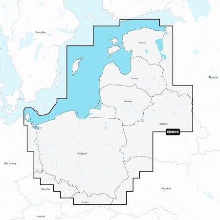
Navionics+ NSEU081R - Baltic Sea, East Coast - Marine Chart Get the world's No. 1 choice in the marine mapping with the best, most up-to-date Navionics+ cartography on your compatible chartplotter. Featuring vibrant colors, a streamlined interface and combined coastal/inland content with a popular Navionics style color palette, Garmin Navionics+ cartography makes it easy to plot your course. Multiple shading options aid in shallow water navigation and make it easy to highlight a target depth range for the best fishing spots. Fully customizable with various chart layers, overlay combinations and up to 10 color-shaded target depth ranges to scope out the best fishing spots. When you purchase a new Garmin Navionics+ or Garmin Navionics Vision+ cartography product, a one-year subscription is included. Chart Code - NSEU081R Coverage Area: Coastal coverage of the Baltic Sea coasts of Poland, Russia, Lithuania, Latvia and Estonia from the German border to Narva-Jõesuu, EE and the lakes and rivers of Poland, Belarus and the Baltic States. Coverage includes the Gulf of Riga, the Szczecin, Vistula and Kurshskiy Lagoons, the islands of Gotland, Saaremaa and Hiiumaa, the Oder, Vistula, Bug, Neman, Emajõgi and Daugava Rivers, Lakes Peipus, Pihkva and Vörtsjäve, the Masurian District Lakes including Lake Jeziorak, Lake Lanskie and Lake Sniardwy and Lakes Snudy/Strusto, Miastra, Batorino, Lukomshoye and Selyava in Belarus. Ports include Tallinn, Estonia; Riga, Latvia; Gydnia and Gdansk, Poland and Kaliningrad, Russia. Features: All-in-one Map Solution - Access detail-rich mapping of coastal features, lakes, rivers and more. Integrated Garmin and Navionics content offers coverage for boaters worldwide. Daily Chart Updates - Charts are constantly being enhanced with new and amended content — as many as 5,000 updates are made every day. The one-year included subscription gives you access to daily chart updates via the ActiveCaptain app. Auto Guidance+ Technology - Combining the best of Garmin and Navionics automatic routing features, built-in Auto Guidance+ technology1 gives you a suggested dock-to-dock path to follow through channels, inlets, marina entrances and more. Depth Range Shading - High-resolution depth range shading l
Ratings & Reviews
3 Reasons You Can Count On Us

Supplies for every job.
10 million items and the exact one you need.

When you need it fast, count on Zoro!
2 million products ship in 1 day.

Stretch your budget further.
Everyday low prices on the brands you love.