Antarctica Satellite Map, Laminated, 31.25in. x 20.25in.
Mfr # RE00620144
Zoro # G315993353
product price: $28.15
/eaKey Features
Includes
1 Map
Recommended Age
14+ years
Recommended Grade
Grade 9+
Color
Multicolor
Material
Paper, Plastic
Get a 10% off coupon
Free 30-day returns
Return PolicyGet 30 days to pay with Net 30
Apply NowReal support from real people
Contact our U.S. based teamSpecifications
Product Information
MFR #
RE00620144
Zoro #
G315993353
UPC #
-
Country of Origin
United States
Details
Includes
1 Map
Recommended Age
14+ years
Recommended Grade
Grade 9+
Color
Multicolor
Material
Paper, Plastic
Description
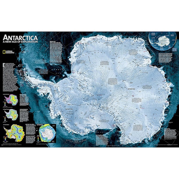
A striking view of Antarctica's terrain, compiled from 4,500 satellite scans. Additional inset maps show surface elevation, ice sheet thickness, velocity of ice flow, and sea ice movement and windflow._x000D__x000D_The map is encapsulated in heavy-duty 1.6 mil laminate which makes the paper much more durable and resistant to the swelling and shrinking caused by changes in humidity. Laminated maps can be framed without the need for glass, so the frames can be much lighter and less expensive.
- National Geographic Antarctica Satellite Wall Map has a striking view of Antarctica's terrain, compiled from 4,500 satellite scans
- Additional inset maps show surface elevation, ice sheet thickness, velocity of ice flow, and sea ice movement and wind flow.
- The map is encapsulated in heavy-duty 1.6 mil laminate which makes the paper much more durable and resistant to the swelling and shrinking caused by changes in humidity.
- Measures 31.25" x 20.25"
Restrictions
Ratings & Reviews
3 Reasons You Can Count On Us

Supplies for every job.
10 million items and the exact one you need.

When you need it fast, count on Zoro!
2 million products ship in 1 day.

Stretch your budget further.
Everyday low prices on the brands you love.