NASA010R - Central America, Caribbean -+
Mfr # 010-C1459-30
Zoro # G212299121
product price: $168.99
/ea
Free Shipping & Returns
Get a 10% off coupon
Free 30-day returns
Return PolicyGet 30 days to pay with Net 30
Apply NowReal support from real people
Contact our U.S. based teamSpecifications
Product Information
MFR #
010-C1459-30
Zoro #
G212299121
UPC #
821245995360
Country of Origin
Taiwan, Province of China
Description
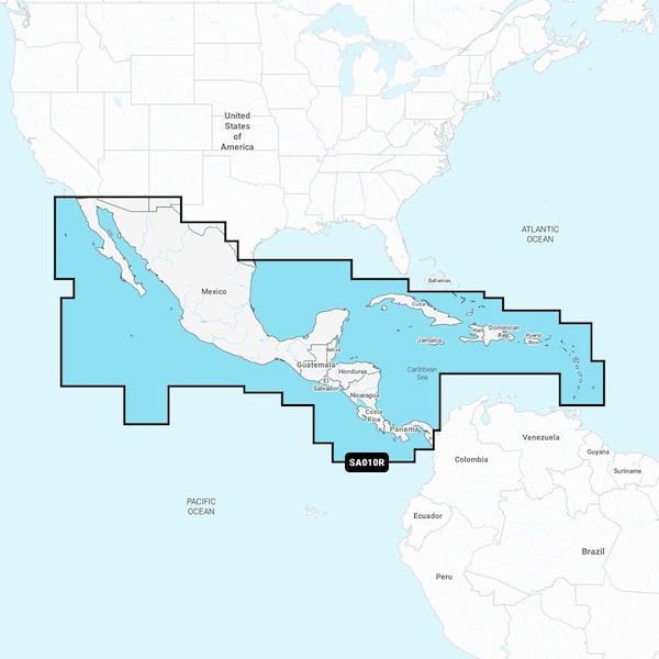
NASA010R - Central America, Caribbean - Navionics+ Get the world No. 1 choice in marine mapping - with the best, most up-to-date Navionics+ cartography on a compatible chartplotter. For offshore or inland waters, this all-in-one solution offers detail-rich integrated mapping of coastal waters, lakes, rivers, and more. Get SonarChart 1’ 0.5 meters HD bathymetry maps and advanced features such as dock-to-dock route guidance technology, live mapping, and Plotter Sync to provide wireless access to daily updates. The Navionics Chart Installer software also ensures the freshest chart data every time. Navionics dock-to-dock route guidance solutions suggest a path to follow through channels, inlets, marina entrances, and more. Multiple shading options aid in shallow-water navigation and make it easy to highlight a target depth range for the best fishing spots. Chart Code: NASA010R Coverage Area: Detailed coverage west coast of Mexico from Tijuana to Panama. Including the Panama Canal in its entirety. East Coast coverage from Panama to Brownsville, TX. Also includes detailed Caribbean coverage of the Far Bahamas, Turks, Caicos, Cuba, Jamaica, the Caymans, Haiti, Dominican Republic, Puerto Rico, and the Lesser Antilles To Grenada. Features: Coastal Content - Offers detail-rich integrated mapping of coastal waters, lakes, rivers, and more Inland Content - 44,000+ lakes Detailed Nautical Charts - Comprehensive charts are derived from multiple officials, government, and private sources, displayed in a familiar look and feel SonarChart HD Bathymetry - Innovative 1ft 0.5 m bathymetry charts are created by using Navionics proprietary systems that augment existing content with sonar data contributed by the boating community Daily Updates - Up to 5,000 daily updates to the charts give the most accurate, most current Navionics data available Dock-to-dock Route Guidance2 - Start the trip with a suggested path Plotter Sync1 - Allows compatible chartplotter owners to transfer routes and markers, update chart layers, and more Community Edits - Get useful local knowledge from edits made by users of the Navionics Boating app on a compatible smart device Advanced Map Options1 - Customize the view to focus on the details that matter most <
Documents & Resources
Ratings & Reviews
3 Reasons You Can Count On Us

Supplies for every job.
10 million items and the exact one you need.

When you need it fast, count on Zoro!
2 million products ship in 1 day.

Stretch your budget further.
Everyday low prices on the brands you love.