Get a 10% off coupon
Free 30-day returns
Return PolicyGet 30 days to pay with Net 30
Apply NowReal support from real people
Contact our U.S. based teamSpecifications
Product Information
MFR #
010-C1367-40
Zoro #
G207966694
UPC #
821245991744
Country of Origin
Unknown
Description
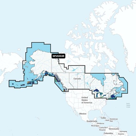
NPUS004R Canada Alaska Get the world's No 1 choice in marine mapping with the best, most uptodate Navionics Platinum cartography on your compatible chartplotter For offshore or inland waters, this allinone solution offers detailrich integrated mapping of coastal waters, lakes, rivers and more Get SonarChart 1' 05 meter HD bathymetry maps, advanced features such as docktodock route guidance technology, live mapping and Plotter Sync to provide wireless access to daily updates The Navionics Chart Installer software also ensures the freshest chart data every time out Navionics docktodock route guidance solutions give you a suggested path to follow through channels, inlets, marina entrances and more Multiple shading options aid in shallow water navigation and make it easy to highlight a target depth range for the best fishing spots Navionics Platinum charts include all the content of Navionics cartography, with integrated offshore and inland mapping, 42,000 lakes and additional viewing options for relief shading, satellite imagery with SonarChart shading overlay, 3D perspective view, aerial photos, and more Chart Code NPUS004R Coverage Area Coverage of the Atlantic and Pacific coasts, inland lakes and waterways of Alaska and Canada except YT and NU Coverage includes the Aleutian Islands, Vancouver Island, Puget Sound, the St Lawrence River, the Maritime Provinces and the Grand Banks Features Nautical Chart Comprehensive charts are derived from multiple officials, government, and private sources, displayed in a familiar look and feel SonarChart HD Bathymetry Innovative 1' 05 m bathymetry charts are created by using Navionics proprietary systems that augment existing content with sonar data contributed by the boating community Community Edits Get useful local knowledge from edits made by users of the Navionics Boating app on your compatible smart device Daily Updates Up to 5,000 daily updates to our charts give you the most accurate, most current Navionics data available 1 Docktodock Route Guidance 2 Start your trip with a suggested path SonarChart Live Mapping Feature Watch new HD depth maps develop in realtime as your boat moves through the water Advanced Map Options Customize your view to focus on the details that matter most Plotter Sync 1 Transfer routes and markers, update chart layers, and more between your compatible chartplotter and the Boating app Relief Shading Get an easy
Ratings & Reviews
3 Reasons You Can Count On Us

Supplies for every job.
10 million items and the exact one you need.

When you need it fast, count on Zoro!
2 million products ship in 1 day.

Stretch your budget further.
Everyday low prices on the brands you love.